
Search
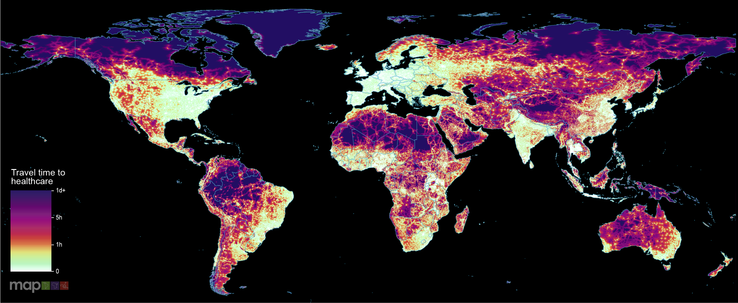
New research which maps the entire global population’s travel time to their nearest healthcare facility has revealed major inequalities in access to healthcare depending on whether people have access to motorised transport or not.
The prevalence of taeniasis in Thailand has decreased over the past six decades. However, it remains a public health concern, particularly in focal areas, especially along the border regions where migration between Thailand and neighboring endemic countries is frequent. Spatial distribution analysis provides a useful method for identifying high-risk areas and implementing targeted integrated control measures. This study aimed to examine the spatial patterns of taeniasis in 2008 and 2014, along with their associated One Health risk factors at the sub-district level.
Vietnam, as one of the countries in the Greater Mekong Subregion, has committed to eliminating all malaria by 2030. Declining case numbers highlight the country's progress, but challenges including imported cases and pockets of residual transmission remain. To successfully eliminate malaria and to prevent reintroduction of malaria transmission, geostatistical modelling of vulnerability (importation rate) and receptivity (quantified by the reproduction number) of malaria is critical.
Worldwide, tuberculosis (TB) remains the leading cause of death from infectious diseases. Africa is the second most-affected region, accounting for a quarter of the global TB burden, but there is limited evidence whether there is subnational variation of TB prevalence across the continent. Therefore, this study aimed to estimate sub-national and local TB prevalence across Africa.
Soil-Transmitted Helminth (STH) infections are a significant health issue in the Western Pacific Region (WPR). This study aims to produce high-resolution spatial prediction STH prevalence maps for the WPR.
Differential exposure and effect of malaria results from blends of biophysical, geospatial, and social determinants of health (SDoH). Likewise, effective policies and programmatic interventions against malaria must consider the complex interaction of social and spatial factors, while comprehensive health promotion approaches must simultaneously tackle SDoH and the ecological dimensions that drive malaria.
Country-level estimates can mask local geographic variations in progress toward achieving World Health Organization's End TB targets. This study aimed to identify spatial variations in progress toward achieving the TB incidence reduction target at a district level in Ethiopia.
Tuberculosis (TB) is the leading infectious cause of death globally, with approximately three million cases remaining undetected, thereby contributing to community transmission. Understanding the spatial distribution of undetected TB in high-burden settings is critical for designing and implementing geographically targeted interventions for early detection and control.
Geostatistical analysis of health data is increasingly used to model spatial variation in malaria prevalence, burden, and other metrics. Traditional inference methods for geostatistical modelling are notoriously computationally intensive, motivating the development of newer, approximate methods for geostatistical analysis or, more broadly, computational modelling of spatial processes.
Traditional birth attendance (TBA) remains common in Sub-Saharan Africa (SSA), impacting maternal and neonatal mortality rates. This study aimed at producing high-resolution geospatial estimates and identifying predictors of TBA-assisted childbirth in SSA.